


PHOTOGRAMMETRY VS. LIDAR PT.1
- OGL
- May 22, 2017
- 3 min read
PHOTOGRAMMETRY VS. LIDAR FOR SURFACE MODELS
Many companies are contemplating a switch from LiDAR to solely photogrammetry for their terrain modeling needs, but is the lower price tag too good to be true? The answer depends on your company's specific needs.
PHOTOGRAMMETRY

Using photogrammetry to create surface models can be a useful method when used appropriately. It is the process of using overlapping stereo images to determine the elevation of a point that is found in both images. This process is repeated automatically to create a digital elevation model of the terrain.
Pros: Photogrammetry performs well in bare earth areas with minimal to no buildings. This can make it a more cost effective method than LiDAR for industries such as mining and aggregates. A 3D model created photogrammetrically will automatically have colour assigned from the images without any additional processing steps. This adds value for interpretation of the data.
Cons: Because photogrammetry requires points to be visible in multiple images, it makes it difficult to model a surface beneath vegetation. If the ground is not visible in the images, its elevation cannot be modeled, only interpolated. There may also be points that are only visible in one image and not another, making it difficult for software to detect matches. A “false match” caused by moving objects can confuse the software and this result is a noisy elevation model, particularly when long shadows are present.
LIDAR

LiDAR (Light Detection and Ranging) uses pulses of light and their time of return to measure precise distances from the sensor to the ground or objects above the ground. Our Leica ALS70 can fire up to 500,000 pulses per second, resulting in a dense point cloud of direct measurements.
Pros: Collection of layered surfaces such as densely forested areas, lattice structures such as substations and transmission poles, and transmission lines is easier to do with LiDAR due to its ability to penetrate porous features. A single LiDAR pulse can reflect off of multiple surfaces making it easier to get returns off of the trees and the ground resulting in a high accuracy model of both the ground surface and the tree canopy surface. Due to the nature of single light pulse measurements, the vertical precision of the point cloud produces more defined profiles of surfaces (as shown in the comparative images below) , as they are a result of a direct measurement.
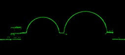
Fig1. 2m Cross Section of a LiDAR Point Cloud

Fig2. 2m Cross Section of a Photogrammetric Point Cloud
Cons: The main hesitation of using LiDAR is typically due to the cost. However, if what you require is a ground surface model under a tree canopy, a high level of detail, or ground models in urban areas, the value may exceed the cost. Without the combination of photogrammetry and LiDAR, there would be no true RGB colour for each point, meaning less context to identify and interpret features in the data.
SUMMARY
LiDAR and photogrammetry methods are both powerful if you use them the right way. The key is finding the correct sensor for your needs. If you are struggling to choose the right approach for your project, our team can work with you to determine the most cost effective and highest value solution to meet your needs.
In order to obtain the accuracy of LiDAR and interpretation benefits from photogrammetry, the best thing to do is combine the two technologies. We will be talking about that in Part 2 so stay tuned!


Comments